
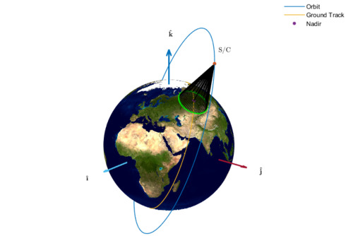
The determination of the coverage area in view of an orbiting satellite is important for the design of satellite constellations providing navigation services such as Global Positioning System (GPS) and Galileo. Indeed, the number of satellites used in the constellation is the minimum to achieve both the requirement of global coverage and accuracy in the position determination. The existing models predict the satellite coverage area assuming the Earth’s shape as a perfect sphere. This assumption can lead to inaccurate results in case of navigation missions.
In their paper Marco Nugnes, Camilla Colombo and Massimo Tipaldi derive a new analytical procedure for the determination of the coverage area in view of an orbiting satellite modelling the Earth’s surface as an oblate ellipsoid of rotation that can increase considerably the accuracy in the predicted measurements.